Maroondah Highway / Yarra Road Intersection Upgrade

  • Project categoryRoads and carparks, Traffic
  • StatusOn-going advocacy
Drone image of the Maroondah Highway and Yarra Road intersection

Council is advocating for major improvements to the Maroondah Highway and Yarra Road intersection and Kent Avenue in Croydon North to improve road safety, congestion and pedestrian accessibility

The estimated cost of these road upgrades is $8M (2022).

Proposed improvements 

  • Removal of the short non-standard left turn slip lane travelling from Yarra Road into Maroondah Highway
  • A complete footpath and shared user path (SUP) network in the vicinity of the traffic signals.
  • A controlled double left-turn from Yarra Road into Maroondah Highway.
  • A controlled and extended double-right turn travelling from Yarra Road into Maroondah Highway.
  • An extended left-turn lane travelling from Maroondah Highway into Kent Avenue.
  • A double right-turn lane travelling from Maroondah Highway into Kent Avenue.
  • New service road accesses and egresses.
  • Removal of the dangerous low-angle slip lane travelling into Yarra Road from Maroondah Highway and replacing it with a longer high-angle left-turn lane.  

View the proposed improvements below in our before and after image slider:

Who is the responsible road authority?

Maroondah Highway is an arterial road. The road and its intersections are managed by VicRoads Department of Transport and Planning (DTP) as the coordinating road authority. Ultimately any improvement proposal is subject to final approval by VicRoads.

Notwithstanding road ownership, Council has proactively undertaken early planning work and design in recognition of the significant benefits that can be delivered to the community. VicRoads Department of Transport and Planning has recognised the value of the project and it is a DTP pipeline project.

What benefits do these improvements provide and what problems will it solve?

A connected and safer pedestrian and cycling footpath environment

Map of footpath issues at Maroondah Highway and Yarra Road
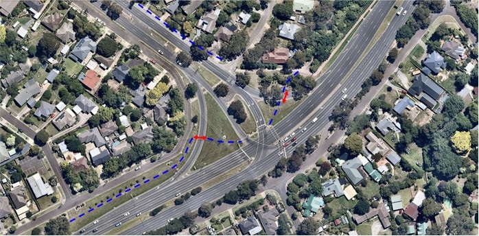
Map of footpath issues at Maroondah Highway / Yarra Road

Due to complexities associated with the layout of the intersection and constraints within the road reserve, there is no formal footpath network within the vicinity of the signals despite the provision of controlled crossings at Maroondah Highway and Yarra Road.  The missing footpath link is shown in the dashed blue line.

This is a particularly poor outcome for accessible users that require a firm and even footing.  Pedestrians are further exposed to non-standard low angle slip lane crossings (red arrows).

A safer left-turn movement from Yarra Road to Maroondah Highway

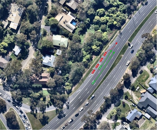
Image showing merge lane issues

The existing left-turn slip and merge lane from Yarra Road to Maroondah Highway is non-standard and does not provide a safe or logical merge movement for motorists.  There is only approximately 50m of merge lane length measured from the tangent point of the curve which is insufficient for a significant portion of motorists to merge safely on to Maroondah Highway.  Motorists are often observed waiting in a stationary position near the end of the merge lane (illustrated in the image above) before attempting to merge into traffic travelling at up to 80km/h from a start-stop; this increases the likelihood of accidents such as rear-ends and side-swipes. 

Crash statistics sourced from VicRoads Road Crash Information System database indicates there has been two reported casualty crashes associated with this merge movement within the last 5 years of available data.  It is noted unreported crashes that do not involve injuries are likely to be significantly higher.

Improved traffic flow

There can be moderate congestion along this section of Maroondah Highway noting the significant residential catchments it is serving towards the north-east.  Yarra Road can be notably congested during the school peak as it is fed by both Plymouth Road and Yarra Road downstream which serve five primary and secondary schools along the routes. 

The proposed design provides the following capacity related improvements:

  • controlled double left-turn lanes into Maroondah Highway from Yarra Road;
  • extension of the existing double right-turn lanes into Maroondah Highway from Yarra Road allowing the movement to clear at the saturation rate;
  • double right-turn lanes from Maroondah Highway into Kent Avenue; and
  • and extended left-turn lane from Maroondah Highway into Kent Avenue.

Engineering design and Traffic Capacity Analysis

A concept engineering design of the intersection has been completed. Traffic modelling indicates that the proposal in terms of traffic capacity will have good level of performance under existing conditions and an ultimate scenario that factors future traffic growth.

View the engineering concept plan of the improvements:

What can you do to help?

Your voice and support is valuable.

Writing to your local/parliamentary representatives and the Department of Transport and Planning will further demonstrate community support and need for the project.  

Further information

For further information on the proposed works, contact Council on 1300 88 22 33 or email maroondah@maroondah.vic.gov.au

Contact details

Location

Maroondah Highway, Yarra Road and Kent Avenue in Croydon North, Croydon North 3136  View map

Google Map